Urban flood-risk mapping is an important tool for the mitigation of flooding in view of continuing urbanization and climate change. However, many developing countries lack sufficiently detailed data to produce reliable risk maps with existing methods. Thus, improved methods are needed that can help managers and decision makers to combine existing data with more soft semi-subjective data, such as citizen observations of flood-prone and vulnerable areas in view of existing settlements. Thus, we present an innovative approach using the semi-subjective Analytic Hierarchy Process (AHP), which integrates both subjective and objective assessments, to help organize the problem framework. This approach involves measuring the consistency of decision makers’ judgments, generating pairwise comparisons for choosing a solution, and considering criteria and sub-criteria to evaluate possible options. An urban flood-risk map was created according to the vulnerabilities and hazards of different urban areas using classification and regression-tree models, and the map can serve both as a first stage in advancing flood-risk mitigation approaches and in allocating warning and forecasting systems. The findings show that machine-learning methods are efficient in urban flood zoning. Using the city Rasht in Iran, it is shown that distance to rivers, urban drainage density, and distance to vulnerable areas are the most significant parameters that influence flood hazards. Similarly, for urban flood vulnerability, population density, land use, dwelling quality, household income, distance to cultural heritage, and distance to medical centers and hospitals are the most important factors. The integrated technique for both objective and semi-subjective data as outlined in the present study shows credible results that can be obtained without complicated modeling and costly field surveys. The proposed method is especially helpful in areas with little data to describe and display flood hazards to managers and decision makers.
Urban Flood-Risk Assessment Through Machine-Learning in Iran
CMES Deputy Director Ronny Berndtsson has co-authored the article "Urban Flood-Risk Assessment: Integration of Decision-Making and Machine Learning" together with Fereshteh Taromideh (Sari Agricultural Sciences and Natural Resources University), Ramin Fazloula (Sari Agricultural Sciences and Natural Resources University), Bahram Choubin (West Azarbaijan Agricultural and Natural Resources Research and Education Center), and Alireza Emadi (Sari Agricultural Sciences and Natural Resources University). The article is available online in the journal Sustainability.
Latest news
29 Mar 2022 | News
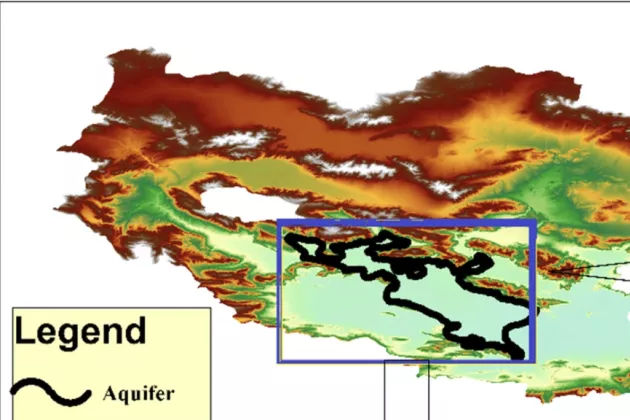
Estimating Sustainable Groundwater Use in Iran Through Machine Learning
CMES Deputy Director Ronny Berndtsson has co-authored an article on estimating sustainable groundwater use in Iran through machine learning.
8 Mar 2022 | News
Measuring Groundwater-Induced Land Subsidence in Iran
CMES scholars Seyed Amir Naghibi, Behshid Khodaei & Hossein Hashemi have authored an article on measuring groundwater-induced land subsidence in Iran.

1 Mar 2022 | News
Predicting Groundwater Levels in Iran
CMES Deputy Director Ronny Berndtsson has co-authored an article on predicting groundwater levels in Iran.